Hiking from the apartment
Walking path to Lake Bled
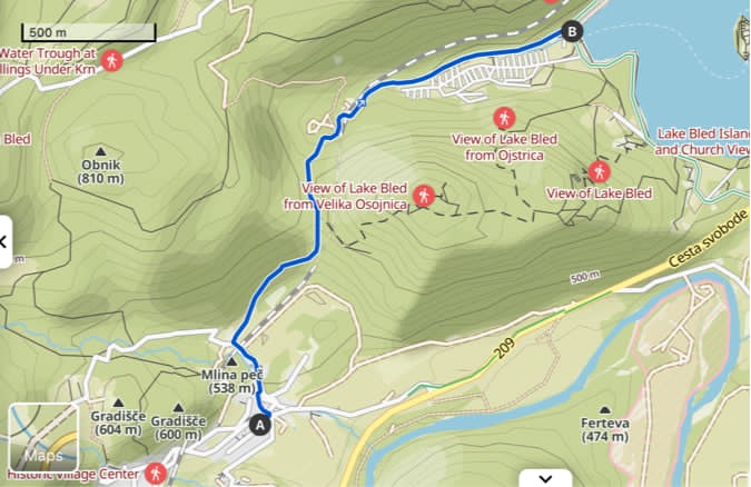
You can reach Lake Bled on foot via a forest pathway. For a nice hike from our apartment to Zaka (Komoot link) at Lake Bled (near Camping Bled), start by heading to the end of the street and turning left. After approximately 5 minutes of walking, enter the forest path and follow the marked hiking trails into the woods. If you're interested in visiting Osojnica (and Ojstrica), there are signs along the pathway indicating where to turn left for a 1-hour detour. Without taking this detour, you can reach the lake in about 30 minutes on foot.
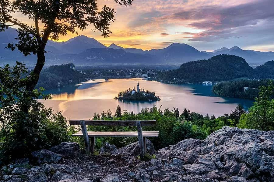
Ojstrica and Osojnica: Enchanting Peaks Overlooking Lake Bled
Ojstrica and Osojnica are two popular viewpoints located near Lake Bled in the Julian Alps, Slovenia. These spots offer breathtaking panoramic views of the iconic lake, Bled Island, and the surrounding mountains. Hikes to these peaks are short yet rewarding, providing a perfect blend of natural beauty and accessible adventure. They are located alongside, therefore it is possible to visit them in one hike. It is possible to reach them from:
Route Overview for Ojstrica
Starting Point: Zaka Campground (Camping Bled)
Ending Point: Ojstrica Viewpoint
Distance: Approximately 1.5 km round trip
Elevation Gain: Around 200 meters
Duration: 30 minutes round trip
More information
Route Overview for Osojnica
Starting Point: Zaka Campground (Camping Bled)
Ending Point: Mala Osojnica Viewpoint and Velika Osojnica Viewpoint
Distance: Approximately 3 km round trip (including both viewpoints)
Elevation Gain: Around 300 meters
Duration: 1 hour round trip
More information
Pathway from Bohinjska Bela to Osojnica
The pathway from Bohinjska Bela to Osojnica offers a scenic route through forested trails and serene landscapes. There signs along the Walking path to Lake Bled indicating where to turn left to visit Osojnica (Ojstrica).
Starting Point: Bohinjska Bela
Ending Point: Mala Osojnica Viewpoint and Velika Osojnica Viewpoint
Distance: Approximately 8 km round trip
Elevation Gain: Around 400 meters
Duration: 3-4 hours round trip
More information - the extended route with a circular route around the lake Bled
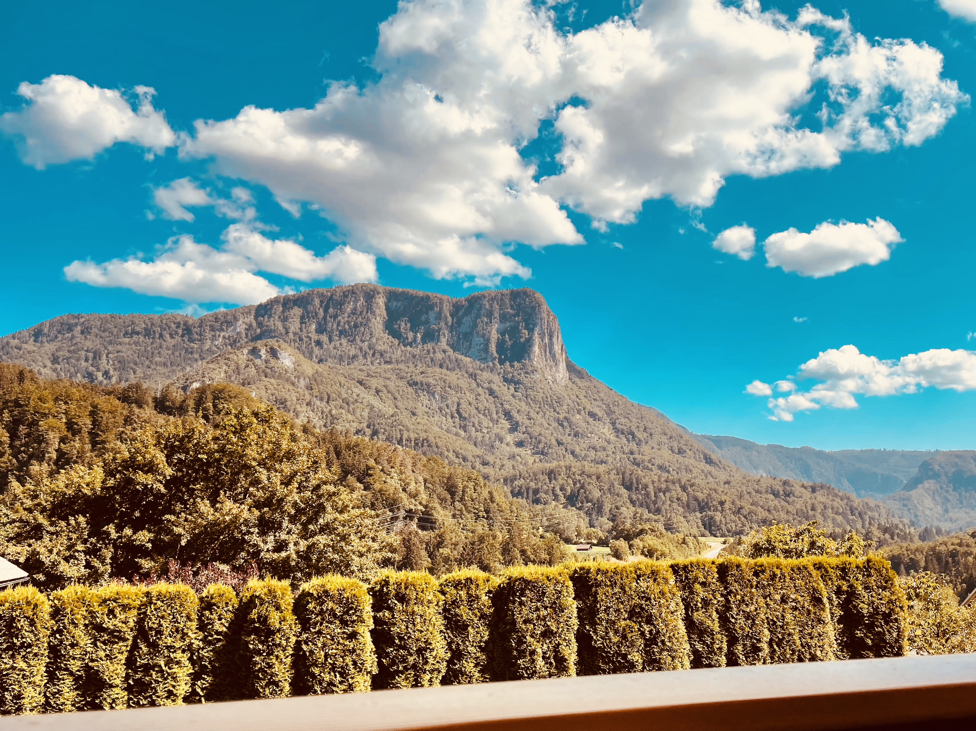
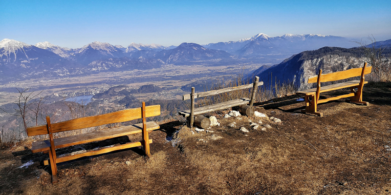
Babji zob
The mountain visible from your balcony or terrace is known as Babji Zob. Hiking to its summit offers a breathtaking panorama of Lake Bled and its surroundings. While the official starting point of the hike is the village of Kupljenik, you can also easily reach the trailhead on foot from your apartment in just 30 - 45 minutes.
Route Overview from Kupljenik
Starting Point: Kupljenik Village
Ending Point: Babji Zob Viewpoint
Distance: Approximately 6 km round trip
Elevation Gain: Around 500 meters
Duration: 3-4 hours round trip
More information
Galetovec
Galetovec offers not only serene alpine vistas but also stunning views of Lake Bled. It is accessible from Bohinjska Bela.
Route Overview from Bohinjska Bela
Starting Point: Bohinjska Bela
Ending Point: Galetovec Meadow or Galetovec Peak
Distance: Approximately 6-8 km round trip
Elevation Gain: Around 500 meters
Duration: 3-4 hours round trip
More information
Hiking in the vicinity
Triglavska jezera (Triglav Lakes)
The Triglav Lakes, also known as the Seven Lakes of Triglav, are a series of picturesque alpine lakes located in the Triglav National Park in Slovenia. The lakes are situated in the Valley of the Triglav Lakes (Dolina Triglavskih jezer) and are named after Triglav, the highest peak in Slovenia and the Julian Alps. These lakes are known for their stunning natural beauty and are a popular destination for hikers and nature enthusiasts.
There are several routes to visit Triglav Lakes. We recommend you to visit Koča pri Triglavskih jezerih via following route:
Route Overview
Starting Point: Blato Meadow (Planina Blato)
Ending Point: Koča pri Triglavskih jezerih (Triglav Lakes Hut)
Distance: 8 km
Elevation Gain: 600 meters
Duration: 3-4 hours one way
More information

Viševnik
Viševnik is a popular mountain in the Julian Alps of Slovenia, known for its stunning views and relatively accessible hiking trails. It stands at 2,050 meters and offers panoramic views of Triglav, the highest peak in Slovenia, and the surrounding alpine landscape.
Route Overview
Starting Point: Rudno Polje (Pokljuka)
Ending Point: Viševnik Summit
Distance: Approximately 3.5 km one way
Elevation Gain: Around 700 meters
Duration: 2-3 hours one way
More information
Zajamniki
Zajamniki is a picturesque alpine pasture located on the Pokljuka Plateau in Slovenia. Famous for its charming wooden cottages and stunning panoramic views of the Julian Alps, it is a serene destination ideal for leisurely walks, photography, and connecting with nature.
Route Overview
Starting Point: Rudno Polje (Pokljuka)
Ending Point: Zajamniki Alpine Pasture
Distance: Approximately 6 km round trip (depending on starting point)
Elevation Gain: Around 50 meters
Duration: 1.5 hours one way
Slemenova spičica
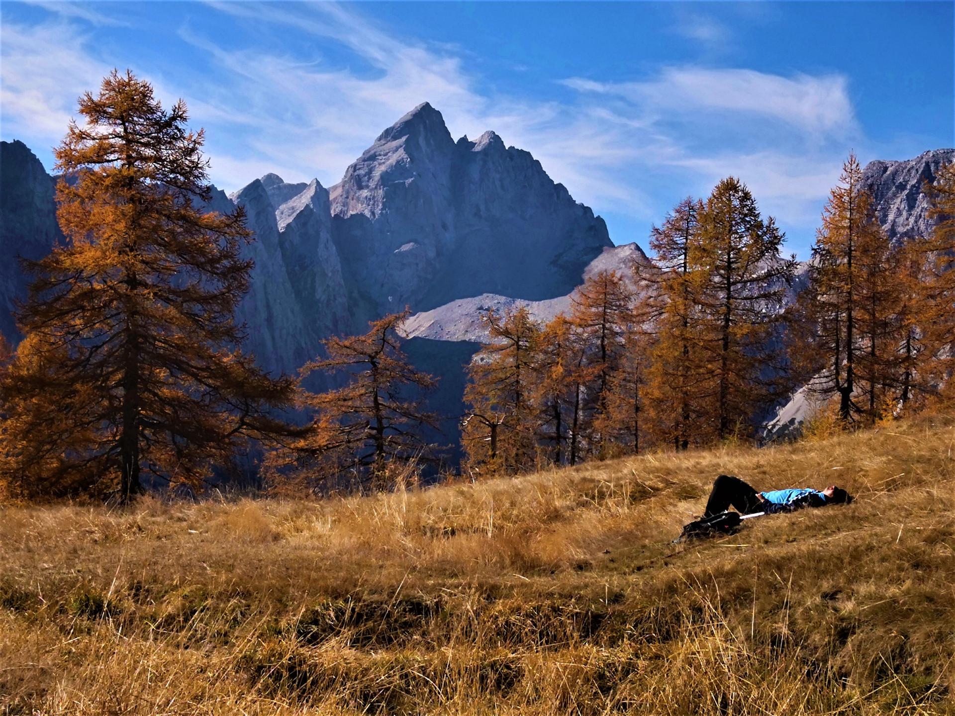
Slemenova Špica is a stunning peak in the Julian Alps, Slovenia, known for its breathtaking views and accessible hiking trails. It stands at 1,911 meters and offers magnificent vistas of the surrounding mountains, including Triglav and Jalovec.
Route Overview
Starting Point: Vršič Pass
Ending Point: Slemenova Špica Summit
Distance: Approximately 5 km round trip
Elevation Gain: Around 350 meters
Duration: 1.5-2 hours one way
More information
Stol
Stol, also known as Hochstuhl, is the highest peak in the Karawanks mountain range, standing at 2,236 meters. It offers a challenging yet rewarding hike with spectacular views.
Route Overview
Starting Point: Valvasorjev Dom
Ending Point: Stol Summit
Distance: Approximately 8-10 km round trip
Elevation Gain: Around 1,055 meters
Duration: 3-5 hours round trip
More information
Mostnica Gorge and Voje Valley
Mostnica Gorge and Voje Valley are beautiful natural attractions located near the town of Bohinj in the Julian Alps, Slovenia. These areas offer stunning landscapes, tranquil hiking paths, and a chance to experience the pristine beauty of Slovenia's alpine region. If you would prefer a shorter hike it is also possible to visit only Mojstrica Gorge.
Route Overview
Starting Point: Stara Fužina
Ending Point: Voje Valley and Mostnica Waterfall (Slap Voje)
Distance: Approximately 12 km round trip
Elevation Gain: Around 300 meters
Duration: 3-4 hours round trip
More information